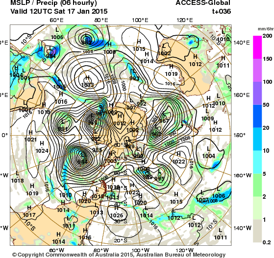
I will post the 4 charts I sent to Anonymous user after showing you the following. They resulted in her telling me off for my bad language. This is the first chart of today’s Bureau of Meteorology. All I can say is that I wish I had collected the charts from the previous run. They do a 6 am set of charts and a 6 pm one. I like to get the 6am one as it makes building animations of a long period a little easier.
I missed this build up:

This is everything, really.The numbers around the square are the lines of longitude in 20 degree intervals. The Greenwich Meridian is the one marked “0” on the left in the middle of the side. Below it is 20 degrees West and below that is 40 degrees West and so on half way around the block.
Above the Greenwich meridian are the degrees East they go around the other way and meet the Western ones at 180 degrees (middle of the right hand side as you look at it.)
OK, so now we all know where we are, the cyclone I want you to look at is on the 20 degree East longitude, directly underneath Africa. The line of blue running through it is precipitation (mist, rain or snow or other words for “water in the sky”.)
When a jet of precipitate runs straight in like that it is a sure sign of an impending earthquake. It goes in along the shortest possible route and arrives with a bang. There is more to it than that of course. Earthquakes run in series. Here is the previous earthquake series:
| 2015/01/16 | 5.0 Mb | VANUATU |
| 2015/01/16 | 4.8 Mb | RYUKYU ISLANDS, JAPAN |
| 2015/01/15 | 4.5 Mb | KEPULAUAN OBI, INDONESIA |
| 2015/01/15 | 5.1 Mb | SOUTHERN MID-ATLANTIC RID |
| 2015/01/15 | 4.7 Mb | NORTHERN SUMATRA, INDONES |
| 2015/01/15 | 4.7 M | CATAMARCA, ARGENTINA |
| 2015/01/15 | 4.4 Mb | Kuril Islands |
| 2015/01/15 | 5.2 Mb | SOUTHERN SUMATRA, INDONES |
| 2015/01/15 | 4.2 Mb | Ukraine-Moldova-SW Russ |
| 2015/01/15 | 4.6 Mb | FIJI REGION |
Each series starts with a quake around Fiji or one of the islands nearby and ends with a quake at or near PNG or Indonesia. This one appears to have ended with a quake at Japan and the next series is about to run from Vanuatu. They usually take a couple of hours to post a report of an earthquake. This is how long it takes to verify a quake and get it’s approximate position and strength.
And then it is passed to other users such as SED.
Or of course, I got it wrong again.


These others are just so many make-weights that I need to show you what else is happening. But I am nodding off having been up most of the night and I am going to be making a mess of all this if I am not careful.
I will finish it off later.


Reblogged this on The Lunatic Society and commented:
«Looks like an interesting series..»